
MANAGERS OF STELLING MINNIS COMMON
AND STELLING MINNIS CHARITABLE TRUST
10 YEAR PLAN
Return to home page Return to Index and Contents
Return to Managers of Stelling Minnis Common & Stelling Minnis Charitable Trust page
Read reviews on the trial grazing area
Read the mystery of the Minnises
Maps To comply with Ordnance Survey copyright rules these maps have been removed from this web page. For a copy of the maps please apply to Ivor Champion (e-mail ivor@bar-billiards.com)
Links: Go straight to the Management plan in its entirety Go to sections index
 |
 |
INDEX OF SECTIONS (Click on numbered section or un numbered sub section to go straight there)
North Kent Downs AONB Policy Statements
Department of Food and Rural Affairs Policy on Maintaining Commons
The Law of Property Act of 1925 (Section 193)
Vehicular Access Across Commons
Countryside Stewardship Scheme
1 POLICY
STATEMENTS
There are a number of policy documents that affect Stelling Minnis Common. They
include the North Downs AONB Policy Statements, the Defra Common Land Policy
Statement, the Countryside and Rights of Way Act 2000 (CROW), The Law of
Property Act of 1925 (Section 193) and the Commons Registration Act, 1965. The
requirements of Defra under the Countryside Stewardship Scheme will also have
implications for the way the site is managed.
Further information on all these policies is given below.
North Kent Downs AONB Policy Statements
There are a number of policies within the Kent Downs AONB Management Plan that
are aimed at:
Conserving and enhancing landscape character and diversity.
Conserving and enhancing biodiversity.
Farming as a custodian of the landscape
Managing woodland and trees
Conserving and celebrating the past
Sustaining natural resources
Supporting vibrant communities
Access, enjoyment and understanding.
Further details may be found within the Kent Downs AONB Management Plan (2004).
Department of Food and Rural Affairs
Policy on Maintaining Commons
A new policy on Commons has recently been produced by Defra (Common Land Policy
Statement – 2002 (a copy of this document may be found on the Defra website –
www.defra.gov.uk )).
The most relevant statement within the document affecting this management plan
refers to the Revision of the Section 194 decision criteria and is concerned
with the decision as to whether to give or withhold consent for fencing or other
works on Commons1.
([1]
Under Section 194 of the Law of Property Act 1925, the erection of any building
or fence, or the construction of any work, which prevents or impeded access to
land which was subject to rights of common on 1 January 1926, is unlawful unless
the consent of the Secretary of State or National Assembly for Wales is
obtained.)
The decision process is now designed to follow a detailed criteria which take account of:
The interests of the public;
The rights of the owners and commoners;
The need for effective management of the common;
The conservation of wildlife and its habitats and of natural and historic features; and
Impact on rights of public access.
It is anticipated that the overall effect of this
policy could be the support for fencing from the Secretary of State, either
temporary or permanent, where it is needed in order to support the effective
management of a Common and its conservation of wildlife, habitats and historic
features.
Countryside and Rights of Way Act 2000
Part 1 of the Countryside and Rights of Way Act 2000 (CROW) gives the public a
new right of access to mountain, moor, heath, down and registered common land.
It also recognises the needs of landowners and managers:
The new right will not extend to cycling, horse riding or driving a vehicle;
Land managers will be allowed to close land for up to 28 days each year;
There will not be access to gardens or parks or to cultivated land.
Further information on CROW is available from the Countryside Agency’s website:
www.countryside.gov.uk.
The Law of Property Act of 1925
(Section 193)
The following is a copy of the Legal Document protecting Stelling Minnis Common.
It has been taken from the Stelling Minnis website:
www.stelling-minnis.co.uk.
LAW OF PROPERTY ACT, 1925. (Section 193)
STELLING MINNIS COMMON
Parish of Stelling Minnis, County of Kent
NOTICE IS HEREBY GIVEN THAT STELLING MINNIS COMMON is subject to the provisions
of Section 193 of the Law of Property Act, 1925, under which members of the
public have rights of access to the Commons for air and exercise.
1. If done on the Common without lawful authority, it is an offence for anyone
exercising the aforesaid rights of access to the Common:-
(i) (a) To draw or drive any carriage, cart, caravan, truck or other vehicle
otherwise than on a public carriage way.
(b) To camp.
(c) To light fires.
(ii)(a) To remove gravel, sand, soil or turf.
(b) To take or attempt to take fish from any pond or stream.
(c) To shoot or wilfully disturb, chase, or take game or other birds or animals.
(d) To permit dogs to chase game or other birds or animals or other-wise fail to
keep dogs under proper control.
(e) To remove or attempt to remove birds' eggs or nests.
(f) To set traps, nets or snares for birds or animals.
(g) To permit horses, cattle, sheep or other animals to graze or stray.
(h) To bathe in any pond or stream.
(i) To post or paint bills, advertisements, placards or notices.
(j) To train or break in horses by grooms or others.
(k) To hold any show, exhibition or fair or place any swing, roundabout or other
like thing.
(l) To construct or place any building, tent, booth, stall, fence, post,
railing, trench, pit, roadway or other similar structure or work for any
purpose.
(m) Generally to injure or disfigure the land or interfere with the use thereof
by the public for the purpose of air and exercise.
2. Any committing such any offence as aforesaid is liable on summary conviction
to a fine not exceeding 40 shillings for each offence.
3. The acts mentioned in paragraph 1 (ii) are forbidden by reason of the
limitations and conditions imposed by an Order dated the Fifteenth day of March,
1954, made by the Minister of Agriculture and Fisheries under the said section
193.
4. The said Order with the relative plan has been deposited at the Public Record
Office, Chancery Lane, London, W.C.2, and a certified copy has been deposited
with the Council of the Rural District of Elham in which the land is situated.
The Order and the Copy will be open to inspection during ordinary office
hours.
W. G. TROWER,
M. E. PUMPHREY,
Dated 17th March, 1954.
Lords of the Manor of Stelling Minnis.
All enquiries to: Stelling Minnis Preservation Committee,
Post Office, Stelling Minnis.
Commons Registration Act 1965
The Minnis is Fully Registered under The Commons Registration Act, 1965. The
1965 Act defines Common land as ‘land subject to rights of common (as defined in
this Act) whether those rights are exercisable at all times or only during
limited periods’ and ‘waste land of a manor not subject to rights of common’ (Defra,
2002).
Vehicular Access Across Commons
The Law of Property Act 1925 says that it is an offence to draw or drive any
carriage, cart, caravan, truck or other vehicle on the Common other than on a
public carriage way if done without lawful authority.
This is reinforced by CROW which, whilst giving
the public a new right of access to registered common land does not extend to
driving a vehicle.
It is understood (Charlie Gooch pers. comm..) that with regards to Stelling
Minnis Common a number of householders have a legal right of way across the
Common to reach their homes.
Countryside Stewardship Scheme
Stelling Minnis Common is currently under a Countryside Stewardship Scheme
agreement that will run from 1st October 2003 – 30th September 2013.
Defra have given the following management prescriptions that will apply to all
agreement land (unless otherwise agreed):
“Inorganic or organic (e.g. farmyard manure) fertiliser, lime, slurry, sewage
sludge or slag, must not be applied.
Pesticides must not be applied except for the control of spear thistle, creeping
or field thistle, curled dock, broadleaved dock, common ragwort or, with prior
Defra agreement, nettles. Application must be by weed wiper or spot treatment.
All pesticides must be applied in accordance with the Control of Pesticide
Regulations 1986 and follow the Code of Good Practice for the safe use of
pesticides on farms and holdings.
There must be no ploughing or other cultivation, reseeding, rolling or chain
harrowing.
There must be no new drainage or major modification to existing drainage
systems. This includes subsoiling and mole ploughing. on Agreement land.
There must be no use of metal detectors or ground disturbance on sites of
archaeological interest without prior written consent from Defra.
The Countryside Stewardship Scheme also provides guidelines for stocking rates
in the form of Livestock Units (LU) per hectare, which will need to be used when
calculating rates for Stelling Minnis Common:
Dairy Cow 1.0
Beef Cow (excluding calf) 1.0
Cattle over 2 years old 1.0
Cattle 6 months to 2 years 0.6
Lowland ewe and lamb 0.15
Hill ewe 0.10
Ram and teg over 6 months 0.15
Horse 1.0
Pony 0.6
2. DESCRIPTION
2.1 General information
2.1.1 Site Name: Stelling Minnis Common
2.1.2 Ownership:
The Common is privately owned by the Trustees of the Estate of the late Lord
Tomlin who held the title of ‘Lord of the Manor’.
Contact: Mr C Gooch (Land Agent)
FPD Savills
Rolfes House60 Milford Street
Salisbsury
SP1 2BP
01722 426800
Email: cgooch@fpdsavills.co.uk
2.1.3 Tenure:
Freehold.
2.1.4 Management Infrastructure:
The Common is managed by The
Managers of Stelling Minnis Common, a group appointed by the Trustees.
Contact: Mr Kevin Smythe (e-mail: smythhome@onetel.com;)
2.1.4.1 Right of Common: Under the Commons Registration Act of 1965, some 46 properties abutting onto the Minnis registered Rights of Common. These rights are Grazing of Animals and Estovers. At the time of Registrations, the total numbers of animals for which Rights were claimed was as follows:
Sheep 1040
Cattle 133
Geese 52
Horses 21
Goats 8
Donkeys 5
Pigs 2
Since the time of Registration, many properties
have changed hands, been merged, or broken up.
An updated list of the Commoners is provided within the ‘Listings Book’. This
book may be obtained through Mr C Gooch (Land Agent) FPD Savills, Rolfes House,
60 Milford Street, Salisbury, SP1 2BP
Stelling Minnis Common has a Commoners’ Association. At the time of writing, it
is believed that no Commoners take advantage of their rights.
2.1.5 Area:
Approximately 124.17 acres, or 50.27 hectares.
2.1.6 District:
Shepway
2.1.7 Planning Authority:
Shepway District Council
2.1.8 Location:
Stelling Minnis Common is located in East Kent, approximately 6 miles south of
the city of Canterbury. The Common is located between two villages, Bossingham
to the north and Stelling Minnis to the south. The road between the two villages
effectively bisects the Common.
2.1.9 OS Grid Reference and Map
Coverage: TR145 474
1:50 000 Landranger 179 – Canterbury and East Kent Area
1:25 000 Explorer 138 – Dover, Folkestone and Hythe
2.1.10 Access:
The site has open access for the general public who have the right to “air and
exercise”. The Common is crossed by a network of paths that link to adjoining
public footpaths. Occupiers of certain properties have vehicular access across
the Common.
2.1.11 Photographic Coverage:
FPD Savills (Sevenoaks Office) has a set of aerial photographs showing on the
properties on the Minnis in 1988.
A vast photographic record of the ancient Minnis exists through the Stelling
Minnis and Upper Hardres Historical Society -
visit web
page for contact details and photograph library.
2.1.12 Compartments or Zones:
The 1993 management plan (Nick Onslow) divided the Common into nine main
compartments, with a number of sub-compartments. The 2004 habitat survey used
these same compartments. However, for the purposes of management the
compartments have been simplified to four. A map showing how the old and new
compartments relate to each other has been enclosed within
Figure 1.
2.2 Environmental Information
2.2.1 Physical: The Common occupies a more-or-less flat area of land varying in height between 140-145 metres above sea level.
2.2.2 Climate: The Climate for the area is typical of southeast England with what might be described as slightly better averages locally.
The table below shows Climate Averages 1971-2000 U.K England and Wye, Kent (Source Meteorological Office Website)
|
|
Max Temp (deg C) |
Min Temp (deg C) |
Days of Air Frost (days) |
Sunshine
(hours) |
Rainfall
(mm) |
Days of Rainfall >=1mm (days) |
|
England January |
6.6 |
1.1 |
11.1 |
50.5 |
84.2 |
13.4 |
|
Wye January |
7.1 |
1.5 |
10.3 |
55.2 |
72.0 |
12.6 |
|
England July |
20.6 |
11.4 |
0.0 |
192.8 |
54.1 |
8.5 |
|
Wye July |
21.3 |
12.2 |
0.0 |
203.1 |
47.1 |
6.8 |
|
England Annual |
13.1 |
5.6 |
49.9 |
1457.4 |
838.0 |
131.2 |
|
Wye Annual |
13.8 |
6.3 |
43.9 |
1603.2 |
727.9 |
116.1 |
2.2.3 Hydrology:
There is no information
currently available concerning the hydrology of Stelling Minnis Common.
2.2.4 Geology: The principle geology of the area is that of the North
Downs. In outline the geology is largely that of the Cretaceous chalk gently
folded by geological activity similar to that of the alpine folding of
continental Europe. Subsequent activity has caused infilling and deposition by
clays and gravels that may be resultant of riverine, surface and erosional
activity.
2.2.5 Geomorphology/Landform: The Common is relatively flat and
represents an area of Brick earth surrounded by clay. The Brick earth is
possibly derived in origin from rocks such as the Thanet or Sandgate Beds and
accounts for the acidic nature of the soils of the common.
2.2.6 Soils:
The soil is a medium clay loam, overlying clay-with-flints,
which in turn overlie chalk. The soil falls into category 1 in the soil water
regime scale (soils with a permeable substrate but remote from ground water).
2.3 Biological
Please note that Compartment numbers given in the following text refer to the
four management compartments shown in Figure 1.
2.3.1 Flora
The vascular plants of Stelling Minnis Common have been relatively-well studied
over the last 15 years or so and a comprehensive plant list has been collated
and included within
Appendix 3.
One county rare vascular plant, western gorse Ulex gallii, is present on the
site. This is its most easterly location in southern England. Western gorse is
only recorded at two other sites in Kent – Aldington Frith and Clowes Wood (Philp,
1982).
The slightly acidic soils on the Common support a characteristic range of
heathland plants that, whilst not of county importance, are none-the-less
localised in terms of their distribution. These include ling Calluna vulgaris,
harebell Campanula rotundifolia and heath bedstraw Galium saxatile.
One species of orchid, common spotted-orchid Dactylorhiza fuchsii has been
recorded growing in grassland in Compartment 2 (Colin Robbins, pers. comm.).
The lower plants appear to have been less well surveyed. Kent Wildlife Trust has
records of two fungus forays having been organised by the Kent Field Club (7th
November 1993 & 4th October 1998). Both visits took place during dry weather and
recorded few species (indeed, no fungi at all were recorded during the 1998
visit). Joyce Pitt and a local resident, Rhona Sutherland, have provided some
records, collected during 2004. The only records for lichens and bryophytes
(mosses and liverworts) come from the Kent Field Club visits, supplemented by
records collected by Joyce Pitt in 2004. Lists of the lower plants found on
Stelling Minnis Common have been included within
Appendices 4 - 6
.
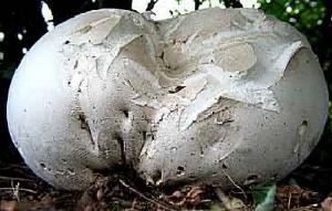
Only 56 species of fungi, 24 species of lichen and 15 species of bryophyte have been recorded. None are rare, but the giant puffball, recorded from woodland in Compartment 4, is of general interest because it is one of the most impressive of the British fungi – individuals the size of a football are not uncommon (see photo right).
2.3.2 Fauna
Lists of the fauna recorded from Stelling Minnis Common have been included
within Appendices 7 - 11.
2.3.2.1 Mammals
A total of 14 mammal species have been reported from the Common including six
that have some measure of protection under statutory legislation. The most
important protected species are described below.
Much badger Meles meles activity was noticed on the Common and a number of setts
were recorded on or adjacent to the Common. Badgers are protected under the
Badgers Act, 1992 and listed on Schedule 6 of the Wildlife and Countryside Act,
1981. Explanations of the levels of protection may be found in the ‘Key to
Abbreviations’ at the start of
Appendix 2
A local naturalist (Martin Newcombe pers. comm.) confirms the presence of
dormouse Muscardinus avellanarius around the edges of the Common; he says that
there is also an old record of dormouse taken from near the Rose and Crown
Public House. Nick Onslow (in McDine (Ed) 1997) mentions pipistrelle bat
Pipistrellus sp. and brown long-eared bat Plecotus auritus on the Common. Both
the dormouse and the bats are listed within the national Red Data Book and are
protected under international and British legislation. The dormouse and the
pipistrelle bat are also both listed within the UK Biodiversity Action Plan as a
‘Priority Species’. Explanations of these terms may be found in the ‘Key to
Abbreviations’ at the start of
Appendix 2.
2.3.2.2 Birds
There seems to have been little structured bird survey work on Stelling Minnis
Common. Kent Ornithological Society has no records for the site, and the main
survey information appears to date from two surveys carried out in 1982 and
1990. There are incidental records from several surveyors including Nick Onslow
(in McDine, 1997) and Fred Booth (2004).
Kent Wildlife Trust has compiled records of 48 species of bird occurring on the
Common (although Nick Onslow (in McDine, 1997) mentions that, ‘some 67 birds
have been noted on or above the common in the last four years’).
Eight species of bird are included on the ‘Red List’ of the Birds of
Conservation Concern 2002-2007 (linnet, yellowhammer, willow tit, house sparrow,
bullfinch, turtle dove, starling, song thrush). The Red List contains species
that are of high conservation concern. All the species here have been included
because they have undergone a decline of more than 50% in their breeding
population in the UK over the last 25 years.
Ten species of bird are included within the Kent Red Data Book (tree pipit,
linnet, yellowhammer, spotted flycatcher, willow tit, house sparrow, bullfinch,
goldcrest, turtle dove, song thrush). The Kent Red Data Book (2000) lists
species that are considered to be rare and threatened in Kent.
2.3.2.3 Reptiles & Amphibians
There appears to have been no coordinated reptile and amphibian survey work
undertaken on Stelling Minnis Common. The Kent Reptile and Amphibian Group has
records of five species of amphibian dating from 1988. Kent Wildlife Trust
carried out a brief survey in 2004 and recorded a number of adult and juvenile
smooth newt Triturus vulgaris and common frog Rana temporaria tadpoles. The
smooth newts were recorded from the pond near Ivy Cottage and from Coxsole Pond;
the frog tadpoles were recorded from Coxsole Pond.
The great crested newt Triturus cristatus (historic record from 1988) is
considered to be the most important amphibian recorded on the Common. It is
protected under international and British legislation. It is also listed within
the UK Biodiversity Action Plan as a ‘Priority Species’. Explanations of these
terms may be found in the ‘Key to Abbreviations’ at the start of
Appendix 2.
The Kent Reptile and Amphibian Group has no records of reptiles from Stelling
Minnis Common. Kent Wildlife Trust has no historic records and, although a
specific reptile search was conducted, no reptiles were recorded during the 2004
survey. However, Nick Onslow (in McDine, 1997) report that grass snake Natrix
natrix, slow-worm Anguis fragilis and viviparous lizard Lacerta vivipara are
well represented. These three species are listed on Schedule 5 of the Wildlife
and Countryside Act, 1981. Protection is limited to killing/injury only.
2.3.2.4 Invertebrates
Invertebrate records for the Common appear to be limited. Most records come from
Nick Onslow in 1992, supplemented with records collected by Norman Heal and
Laurence Clemons during a Kent Field Club visit to the site on 24th July 1993.
Kent Wildlife Trust has compiled records of 19 species of butterfly, 66 species
of moth, 76 species of beetle, three species of dragonfly and damselfly, one
species of spider, four species of true bug, four species of fly, one earwig and
four species of grasshoppers and crickets. Nick Onslow (in McDine, 1997)
mentions that, ‘of the 25,000 British insect species, some 300 have been listed
including 22 species of butterfly.’
There are three nationally notable beetles - Malthinus balteatus, Abdera
biflexuosa and Anaspis thoracica. There are also records of 22 beetle species
and seven moth species that, whilst not uncommon, are considered to be very
localised in their distribution.
There is an interesting record of glow worm Lampyris noctiluca from the Common.
Although they can be found on a wide range of soil types, glow-worms seem to be
particularly abundant on chalk. The habitats where glow-worms occur generally
support healthy populations of snails – the primary food source of this species
(Tyler, 1994). This appears to go against the current situation at Stelling
Minnis where snails are present in low numbers due to an absence of calcium from
the acidic soils (Stuart, 2002).
2.4 Communities
A number of habitat surveys have been undertaken on the Common within the last
15 years. These include: The Phase 1 Habitat Survey of Kent, undertaken by KCC
in the early 1990s; the Integrated Habitat Classification Survey of Kent,
undertaken by KCC in the early 2000s; an updated Phase 1 Habitat Survey,
specifically of the northern part of the Common carried out by Frances Stuart in
2002; and an extended Phase 1 Habitat Survey undertaken by Joyce Pitt in 2004 in
connection with the revision of the management plan.
These surveys indicate that the main habitats found within Stelling Minnis
Common are:
Lowland Heathland Mosaic
Wood Pasture
Ponds
Broadleaved Woodland and Scrub
Intensively Managed Neutral Grassland
Further information on each of these main habitat types is given below. A copy of the Phase 1 Habitat Survey (2004) has been included within Appendix 12.
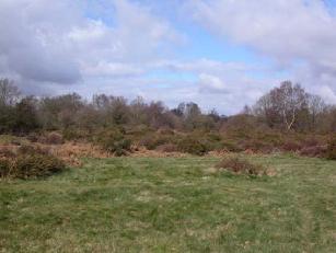
2.4.1 Lowland Heathland Mosaic
 The
largest block of heathy vegetation occurs to the east of Bossingham Road
(Compartment 2; see photo right), although fragments of heathy vegetation are
found throughout the main acid grassland mosaic (Compartments 2, 3, 4). A map
showing the distribution of this habitat type has been included within
Figure 4.
The
largest block of heathy vegetation occurs to the east of Bossingham Road
(Compartment 2; see photo right), although fragments of heathy vegetation are
found throughout the main acid grassland mosaic (Compartments 2, 3, 4). A map
showing the distribution of this habitat type has been included within
Figure 4.
Heathy vegetation tends to occur on thin, acid, sandy soils and is characterized by the presence of ling Calluna vulgaris, gorse Ulex europaeus and the county rare species western gorse Ulex gallii. It is also often associated with bracken Pteridium aquilinum and seedling trees of birch Betula pendula and oak Quercus spp.
2.4.2 Wood Pasture
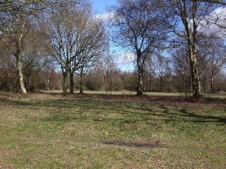
Wood Pasture has been defined here as the intricate mosaic of acid grassland and neutral grassland with scattered semi-mature trees and scrub. It forms the primary habitat within Stelling Minnis Common and is found primarily within Compartments 2, 3 and 4 (see photo left). A map showing the distribution of this habitat type has been included within Figure 3.
 The
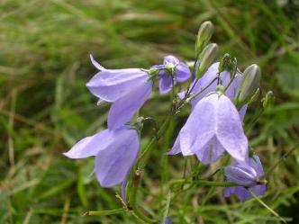
acid grassland on the Common is typical of this habitat generally in that it is
species-poor. However, it supports a range of characteristic plant species such
as harebell Campanula rotundifolia (see photo, right), pill sedge
Carex pilulifera, heath bedstraw Galium saxatile, heath wood-rush
Luzula multiflora and sheep’s sorrel Rumex acetosella. There are
also patches of bracken. Shrubby species include the county rare western gorse
and ling Calluna vulgaris. Semi-mature trees include silver birch
Betula pendula and pedunculate and sessile oak Quercus robur and
Quercus petraea.
The
acid grassland on the Common is typical of this habitat generally in that it is
species-poor. However, it supports a range of characteristic plant species such
as harebell Campanula rotundifolia (see photo, right), pill sedge
Carex pilulifera, heath bedstraw Galium saxatile, heath wood-rush
Luzula multiflora and sheep’s sorrel Rumex acetosella. There are
also patches of bracken. Shrubby species include the county rare western gorse
and ling Calluna vulgaris. Semi-mature trees include silver birch
Betula pendula and pedunculate and sessile oak Quercus robur and
Quercus petraea.
Generally speaking, it should be noted that much of the wood pasture (as defined above) is considered to be a fairly new habitat for the Common, developing as a result of a reduction in the intensity of grazing. The trees that are growing here are relatively young and there are no large specimens of typical wood pasture trees present.
2.4.3 Ponds
Three ponds and one former pond were located on the Common:
Pond opposite Yew Tree Cottage (Compartment 1).
Pond near Ivy Cottage (Compartment 1).
Coxsole Pond (Compartment 4).
Former pond north of Bramble Cottage (Compartment 2).
A map showing the location of the ponds has been given in Figure 5.
All of the ponds were in a poor condition, overgrown and over-shaded. The former pond north of Bramble Cottage had little evidence of any aquatic vegetation and is believed to have been holding water only because of recent rains at the time of the survey.
 The
ponds supported a range of aquatic plant species such as great willowherb
Epilobium hirsutum, yellow iris Iris pseudacorus, bulrush Typha
latifolia, floating sweet-grass Glyceria fluitans, water-crowfoot
Ranunculus aquatilis and common water-starwort Callitriche stagnalis.
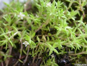
Coxsole Pond supports a substantial patch of the highly invasive, non-native
plant New Zealand stonecrop Crassula helmsii (see photo, right).
The
ponds supported a range of aquatic plant species such as great willowherb
Epilobium hirsutum, yellow iris Iris pseudacorus, bulrush Typha
latifolia, floating sweet-grass Glyceria fluitans, water-crowfoot
Ranunculus aquatilis and common water-starwort Callitriche stagnalis.
Coxsole Pond supports a substantial patch of the highly invasive, non-native
plant New Zealand stonecrop Crassula helmsii (see photo, right).
2.4.4 Broadleaved woodland and scrub
Blocks of woodland and scrub are scattered throughout the Common. The largest blocks of woodland are present in Compartments 1 and 2. A map showing the distribution of this habitat type has been included within Figure 7.
All of the woodland is considered to be secondary i.e. it is recent in origin (none of it is shown on the provisional Ancient Woodland Inventory for Kent (1994)). It is primarily broadleaved and includes species such as pedunculate oak Quercus robur, birch Betula pendula, willow Salix spp., holly Ilex aquifolium, sycamore Acer pseudoplatanus, hawthorn Crataegus monogyna and blackthorn Prunus spinosa.
The scrub was also recent in origin. Much of it was dense and even-aged and supported species such as elder Sambucus nigra, hawthorn and sallow Salix cinerea subsp. oleifolia, with young tree saplings of pedunculate oak and birch. Patches of the county rare plant, western gorse and gorse Ulex europaeus have also been included within the scrub category.
2.4.5 Intensively Managed Neutral Grassland
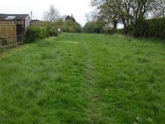 The
intensively managed neutral grassland on Stelling Minnis Common includes areas
of grassland found predominantly at the southern end of the Common and along the
western boundary. It comprises the road verges, grassy tracks and paths and the
grassy areas immediately outside houses (see photo, right). It is also present
in discrete areas elsewhere within the Common and generally occurs where soils
are deeper, or where there has been enrichment or disturbance. A map showing
the main distribution of this habitat type has been enclosed within
Figure 6.
The
intensively managed neutral grassland on Stelling Minnis Common includes areas
of grassland found predominantly at the southern end of the Common and along the
western boundary. It comprises the road verges, grassy tracks and paths and the
grassy areas immediately outside houses (see photo, right). It is also present
in discrete areas elsewhere within the Common and generally occurs where soils
are deeper, or where there has been enrichment or disturbance. A map showing
the main distribution of this habitat type has been enclosed within
Figure 6.
This grassland was dominated by grasses and coarse species such as docks Rumex spp., thistles Cirsium spp., and nettles Urtica dioica. Flowering plants were limited to very common species such as daisies Bellis perennis, buttercups Ranunculus spp., and plantains Plantago spp..
2.5 Cultural
2.5.1 Archaeological/Past Land Use
The following information has been taken directly from, ‘A Plan for the Grazing of Commoners’ Animals on the Common Land of Stelling Minnis in Kent (prepared by the Conservators of Stelling Minnis, 1985). No additional research into Past Land Use has been undertaken.
“Opinions on the origin of Stelling Minnis differ.
One explanation is that of “Stealla’s people” – an ancient tribe. Stealingas and Stellinges – 1086. Stellinges – c. 1100. Stelling – 1240.
Another opinion suggests ‘Stelling’ as ‘stalling’, e.g. a place of shelter for animals.
Minnis – in the Old English “gemaennes” – means “land held in common” or “land of the community”.
Stelling Minnis is one of the last manorial Commons remaining in Kent
Stelling Minnis was recorded in the Domesday Book as part of the possessions of Odo, Bishop of Bayeux, and half-brother of King William.
Stelling Minnis is one of the very few remaining unenclosed and largely unaltered relics of the mediaeval manors and one that is therefore worthy of preservation in its true state and entirety for the good of the County of Kent and its people.
This was the “Lords Waste” of the Manor of Stelling.
There were other “minnises”, but many of them have disappeared (viz: Swingfield, Rhodes, etc.).
The “waste” was a parcel of land reserved for the serfs and labourers who did not own land of their own which they could cultivate either individually or collectively. On this land they were allowed to graze their cow, goat, sheep or pig; to collect firewood, forage and bedding, in the form of bracken and furze, and material to roof their hovels and to try to improve their wretched existence.
Later, many were to enclose small portions of land (either legally or illegally) by “casting up a dyke”, planting a quickthorn hedge atop of it and so making an enclosure. There are a few typical examples on the Minnis today of this type of enclosure. Some were driven off almost immediately, others survived and passed on their enclosures.
The survivors’ descendents became the farmers and smallholders of later years, putting out their cattle and sheep and so acquiring “Prescriptive Rights” over the pasture and other growths.
Years later, these Rights, which had always been jealously guarded, were to be confirmed under the Commons Registration Act of 1965.
But it was not easy to continue to use them on account of a process called ”civilisation”!
We explain how this affected Stelling Minnis later in this document.
Stelling Minnis in Hasted’s time
The great historian of Kent, HASTED, in his ‘History and Topographical Survey of the County of Kent’ (1778-1799) wrote as follows:
“The heath called Stelling Minnis, comprehends most of the parish, extending across it and a considerable way beyond. It is along the whole of it interspersed with houses and cottages, many of which are built on the middle of it, with fields and orchards taken out of it and inclosed around them, which form altogether an uncommon and not unpleasant scene, the inhabitants of them being as rude and wild as the country they live in. These dwellings on the Minnis may be said to form the village of Stelling, for there is no other. A little beyond the Minnis stands the Church, on a hill, and a little further the Court Lodge, at the northwest boundary of the parish.”
Thus we see that a lot of “casting up of dykes” and “inclosing” had taken place by Hasted’s time.
He implies that the Minnis was large – probably much larger before the Inclosure Act of 1845 – for there is a larger acreage of freehold land to the south of the present Minnis known to locals as ‘High Minnis’.
There was a huge encampment of troops on and around Stelling Minnis at the time of the Napoleonic Wars. They were there to repel a possible landing by the Emperor on the southeast coast. The last relic of this period (knocked down many years ago and replaced by the present line of Council dwellings known as ‘Minnis Green’) was Barrack Cottages.
The Minnis up to the 1920s
We know that Stelling Minnis was in active use as a grazing area for Commoners’ animals until a few years after the First World War. Field gates stood across the public highways where they entered the Minnis. We have indications of this from the names of properties – Hatch Farm and Gate Cottage – and older residents have clear memories of the gates.
So, the Minnis interior could be safely grazed by the Commoners’ sheep and cattle.
“Livestock Grazing” highway warning signs are proudly preserved at the entrances to the Minnis.
‘Civilisation’ comes to Stelling Minnis
With the post World War One era came the time of the motor car and motor bus. Before that, the residents lived in a ‘pony and trap’ age and no-one minded getting off to open and close gates.
But soon the protective gates fell into disuse – and it is suspected that some were helped on their way to extinction by the automotive entrepreneurs!
Grazing virtually ceased when the gates went, though “controlled” grazing continued on a small scale until the late 1950s.”
A traditional cattle and sheep ‘fair’ was held twice a year on the Minnis for over a century. Apparently, due to rising costs, this event became uneconomic for the Auctioneers and the ‘fair’ was discontinued in 1984 (The Conservators of Stelling Minnis, 1985; McDine, 1997).
2.5.2 Present Land Use
Stelling Minnis Common is well used by the general public for informal recreation, dog-walking and horse-riding.
A number of local residents have the rights of vehicular access across the Common to reach their homes.
There is also some dumping (particularly of garden rubbish and litter), fenced and un-fenced encroachment of the Common, planting of non-native species on the Common and parking (Onslow, 1993).
2.5.3 Past Management – Nature Conservation
The following information concerning the early nature conservation management of Stelling Minnis Common has been provided by Ann Day.
“In the 1970s, the Conservators of the Stelling Minnis called for a public meeting after complaints from the inhabitants about the state and lack of maintenance on the Minnis. The Conservators informed the meeting that they did not have any funds and it was at this meeting that, ‘The Friends of Stelling Minnis’ were formed by several local people (including Ann Day). In the following years the Friends raised on average about £2000 per annum and this was spent as frugally as possible to mow and clear the Minnis where possible. Also clearance parties were formed to remove all detritus, dead wood and brambles.”
The following information has been summarised from the Minutes of the Meeting of the Trustees and Managers of Stelling Minnis Common (13th Jan 2003).
In 1993, the Common was accepted into the Countryside Stewardship Scheme and a structured Management Plan was produced by Nick Onslow.
“The key features were:
The planned clearance and control of scrub carried out in a manner which preserved the character of the Common whilst following accepted conservation management principles which maximised diversity of aspect, age structure and graded edges.
Scrub clearance and management that favoured native species and controlled invasive aliens.
Scrub management that favoured gorse and heather by selective cutting, careful micro-management and targeting areas where recolonisation by heathland flora was most likely to happen.
Grassland management which would favour heathland species.
Pond management.
Bracken control – focussing on latent and relict heath areas.”
The site was grazed by sheep for a few years, but
the practice was discontinued due to operational difficulties. The grazing was
replaced by, “an intensive mowing and raking regime. This has been the single
greatest annual cost for the Managers.”
The original Countryside Stewardship Scheme expired in 2003. This was renewed
and runs from 1st October 2003 – 30th September 2013.
 The
photograph on the right shows grazing on Stelling Minnis, to the rear of ‘Tralee’,
in 1989. The photograph was taken by Judith Baker and passed to Kent Wildlife
Trust during the public consultation exercise in January 2005.
The
photograph on the right shows grazing on Stelling Minnis, to the rear of ‘Tralee’,
in 1989. The photograph was taken by Judith Baker and passed to Kent Wildlife
Trust during the public consultation exercise in January 2005.
2.5.4 Present Conservation Status
The Common to the north of Crown Lane has been designated as a Site of Nature
Conservation Interest (SH29: Stelling Minnis Common & Church Wood). This means
that the site is considered to be of county wildlife importance. Whilst this is
a voluntary designation, the information is passed to English Nature and the
Local Authority for consideration for inclusion within the Local Plan. A copy of
the schedule has been enclosed within
Appendix 1.
The site was first designated in 1985 and revised in May 2003. The reasons for
designation are as follows:
“Most of this site consists of the Common, which is an important area of
unimproved acid grassland and heath (both rare habitats in Kent) with scrub. Key
species include tree pipit and willow tit (UK Red List), and western gorse (rare
in Kent).”
The block of heathy vegetation to the east of Bossingham Road (Compartment 2)
has been omitted from the designation. It will be included at the next revision.
Stelling Minnis Common lies within the Kent Downs Area of Outstanding Natural
Beauty. It was designated in July 1968. The three main purposes of AONB
designation are:
To conserve and enhance natural beauty.
In pursuing this main objective, account should be taken of the needs of agriculture, forestry, other rural industries, and of the economic and social needs of local communities.
The demand for recreation should be met in so far as it is consistent with the conservation of natural beauty and the needs of agriculture, forestry and other uses.
2.5.4 Landscape
Stelling Minnis Common occupies a linear area bordering the Stelling Minnis to
Bossingham Road for approximately 1-1½ miles. The topography is level with
scattered areas of scrub vegetation and trees. To each side the Common merges
into private dwellings and agricultural land delineated by unobtrusive barriers
of hedges in places obscuring more substantial fences.
The Kent Downs AONB is characterised by the presence of chalk downland and
woodland shaws. Stelling Minnis Common sits on a sandy ‘lens’ which has given
rise to its acid grassland and heathy areas and, in a landscape context, it is
unique within the AONB.
2.5.5 Public Interest/Community
Relations
There is a great deal of interest shown by local residents in the state and
management of Stelling Minnis Common. In the past the perception has been that
there has been a certain amount of reluctance by the Managers and Owners to
involve residents in decisions about management to the extent that, on occasion,
residents have complained of a sense of disenfranchisement with the overall
management of the Common.
The undesirable nature of this situation was recognised by the owners and
Managers over two years ago and a number of new managers were appointed to widen
community involvement. Additionally, the Parish Council is invited to send a
representative to all Managers meetings.
There was an extensive public consultation process as part of the production of
this plan aimed at redressing the balance. The results of the public
consultation were taken into account by the Managers when considering the extent
of management work that would be included within this management plan.
2.5.6 Educational Use/Facilities
The local school (Stelling Minnis CEP School, Bossingham Road, Stelling Minnis)
incorporates activities on the Common within its educational work. Currently the
school is working with Creative Kent to prepare a history of the flora and fauna
of the Minnis (Andrew Barchi, pers. comm.). The Headteacher (Mrs B. Norman) is
keen to extend the use made of the Common.
The school has also been working with educational staff from Kent Wildlife Trust
to explore the educational opportunities provided by the Common.
There are no facilities, such as car/coach parking, toilets, teaching shelter,
pond-dipping platforms or hand-washing facilities.
2.5.7 Research Use/Facilities
A Management Plan and Phase 1 survey of the area of Common to the north of Crown
Lane was produced by Frances Stuart (2002) as part of an undergraduate course.
The Common is periodically visited by members of the Kent Field Club. Results
are normally published in the Bulletin of the Kent Field Club, produced
annually.
2.5.8 Recreational Use/Facilities
Recreational use of the Common is low key (see under Present Land Use for
further details).
There are no facilities, such as car parking, toilets or official play areas.
2.6 Bibliography
Betts, C.J. 2001. Checklist of Protected British Species. Christopher Betts
Environmental Biology, Worcester.
Bright, P., Morris, P., & Mitchell-Jones, A. 1996. Dormouse Conservation
Handbook. English Nature, Peterborough.
Defra. 2002. The Common Lands of Kent: A biological survey. Rural Surveys
Research Unit (University of Wales, Aberystwyth).
Fungus Conservation Forum. Managing your land with fungi in mind. Fungus
Conservation Forum.
Gregory, R.D., Wilkinson, N.I., Noble, D.G., Robinson, J.A., Brown, A.F.,
Hughes, J., Procter, D.A., Gibbons, D.W., and Galbraith, C.A. 2002. The
population status of birds in the United Kingdom, Channel Islands and Isle of
Man: an analysis of conservation concern 2002-2007. British Birds 95: 410-450.
Kent Biodiversity Action Plan Steering Group. 1997. The Kent Biodiversity Action
Plan. Kent County Council.
Kent Downs AONB. 2004. Kent Downs AONB - A management Plan for 2004-2009. Kent
Downs AONB Unit.
McDine (Ed.). 1997. Bossingham & Stelling Minnis Memories. Windmill Publishing
Consultants, Mill Cottage, Mill Lane, Stelling Minnis, Kent CT4 6AF.
Onslow, N. 1993. Stelling Minnis Common Management Plan. Unpublished.
Philp, E.G. 1982. Atlas of the Kent Flora. Kent Field Club.
Stuart, F. 2002. Draft Management Plan, Stelling Minnis Common. Unpublished.
The Conservators of Stelling Minnis. 1985. A Plan for the Grazing of Commoners’
Animals on the Common Land of Stelling Minnis in Kent. Unpublished.
Tyler, J. 1994. Glow-worms. Tyler-Scagel, Tadorna, Bradbourne Vale Road,
Sevenoaks, Kent TN13 3DH.
Waite, A (Ed). 2000. Kent Red Data Book. Kent County Council.
Figure 1:
Stelling Minnis compartment map
Because of Ordnance survey copyright restrictions this map is only available on application to the Managers and conservators of Stelling Minnis Common. Click here for more information on obtaining a copy of the map.
(The Minnis is divided into 4 compartments numbered 1-4 from North to South East.)
3. CONFIRMATION OF FEATURES
3.1 The site in wider perspective and implications for
management
The management history of Stelling Minnis Common appears to be reasonably
well-documented and will be of valuable assistance in determining the forces
that have shaped the Common, as well as contributing the decisions for
appropriate ongoing management.
Stelling Minnis Common is likely to be of increasing biological importance as
the heath/heather regeneration increases and, if grazing is successfully
re-established, it could potentially become a model for other sites where
landowners, managers and communities wish to consider grazing as an effective
management tool. In addition, Stelling Minnis Common has the potential to be of
regional importance in contributing to our increasing knowledge of habitat
management techniques.
3.2.1 Provisional list of important features
The important features listed within this section have come from the SNCI
schedule and from biological information collated as part of the management
planning process.
|
Feature |
Listed on SNCI Schedule |
Collated as part of management planning process |
Status |
Habitats |
|
|
|
|
Unimproved acid grassland |
ü |
|
County Important. UKBAP Priority Habitat. |
|
Heathy vegetation |
ü |
|
County Important. UKBAP Priority Habitat. |
|
‘Wood Pasture’ |
|
ü |
County Important. UKBAP Priority Habitat |
|
|
|
|
|
Species |
|
|
|
|
Great crested newt |
|
ü |
Nationally Important. Protected. UKBAP Priority Species |
|
Badger |
|
ü |
Protected |
|
Dormouse |
|
ü |
Nationally Important. Protected. UKBAP Priority Species. |
|
Pipistrelle bat |
|
ü |
County Important. Protected. UKBAP Priority Species. |
|
Brown long-eared bat |
|
ü |
County Important. Protected. |
|
Western gorse |
ü |
|
County Important. |
|
Tree pipit |
ü |
|
County Important. UKBAP Species of Conservation Concern. |
|
Willow tit |
ü |
|
County Important. UKBAP Species of Conservation Concern. |
|
Redpoll |
ü |
|
County Important. |
|
linnet |
|
ü |
County Important. UKBAP Priority Species. |
|
yellowhammer |
|
ü |
County Important. UKBAP Species of Conservation Concern. |
|
house sparrow |
|
ü |
County Important. |
|
bullfinch |
|
ü |
County Important. UKBAP Priority Species. |
|
turtle dove |
|
ü |
County Important. UKBAP Priority Species. |
|
song thrush |
|
ü |
County Important. UKBAP Priority Species. |
|
spotted flycatcher |
|
ü |
County Important. UKBAP Priority Species. |
|
goldcrest |
|
ü |
County Important. UKBAP Species of Conservation Concern. |
|
Malthinus balteatus (a soldier beetle) |
|
ü |
Nationally Scarce. |
|
Abdera biflexuosa (a beetle) |
|
ü |
Nationally Scarce. |
|
Anaspis thoracica (a tumbling flower beetle) |
|
ü |
Nationally Scarce |
3.3 Evaluation
3.3.1 Evaluation for nature conservation
The total registered area of Commons in Kent is 747 hectares. The majority of
Commons in the county are quite small. Nearly 53% are less than 1ha in size.
Only five Commons, including Stelling Minnis Common, have areas in excess of 50
hectares (Defra, 2002). This makes Stelling Minnis Common important within a
county context.
Although the area of Common land is extremely fragmented to the south of Curtis
Lane, and is also bisected by the Bossingham Road, the main area of Common,
comprising Compartments 1, 2, 3 and the northern part of Compartment 4 provides
a more-or-less unbroken area of ‘wood pasture’. The continuous area of acid
grassland within these compartments is particularly important as lowland acid
grassland in Kent tends to be very fragmented. Indeed the size of the acid
grassland area here was one of the reasons for its designation as a Site of
Nature Conservation Interest.
The Common supports a diversity of habitats and species that reflect the local
geology/geomorphology and management. Three of the habitats present on the
Common (‘wood pasture’, acid grassland and heathy vegetation) are listed as
Priority Habitats within the UK Biodiversity Action Plan and are also considered
to be of County Importance (they have specific Habitat Action Plans within the
Kent Biodiversity Action Plan. Copies of the UKBAP and Kent BAP Habitat Action
Plans have been enclosed within
Appendix 14.
Wood pasture is generally considered to be the highest priority (and most
valuable) woodland habitat type nationally. This is because established wood
pasture supports important communities of lichens, invertebrates (especially
dead wood species), fungi and hole-nesting birds. It is also important for the
areas of unimproved acid grassland that it supports. This habitat was widespread
in the lowlands from medieval times until the early 19th century, but much has
been lost due to conversion to other types of woodland and agriculture. (Kent
BAP, 1997).
The wood pasture at Stelling Minnis Common has developed as a result of the
reduction in the intensity of grazing in recent decades. It is a young and
developing habitat type which, with the exception of the acid grassland, has not
yet established many of the important features mentioned above. The trees that
are growing here are relatively young and there are no large specimens of
typical wood pasture trees. However, opportunities to create and sustain new
areas of wood pasture are becoming increasingly rare. It is therefore
recommended that this habitat should be fully maintained as an integral part of
the Common.
The current extent of lowland acid grassland in Britain is not accurately known,
but it is becomingly increasingly rare in Britain. It can provide an important
reservoir of rare species. However in Kent the habitat is very fragmented (there
are approximately 737.5ha of acid grassland in Kent, occupying less than 0.2% of
the county area). The highest quality acid grassland tends to be managed by
grazing (Kent BAP, 1997). The acid grassland on Stelling Minnis occupies a
relatively large, continuous area and is mainly concentrated within the wood
pasture. It is relatively species-poor, which is a characteristic of this
habitat generally, and was one of the primary reasons for designation as a Site
of Nature Conservation Interest. It is recommended that this habitat should be
managed in line with recommendations for the wood pasture.
Kent is at the eastern end of the main heathland blocks of southern England and
the lowland heathland found here tends to be less species rich than that found
elsewhere. Kent holds a very small amount of heathland (approximately 87
hectares) that is mainly very fragmented and not large enough to support suites
of rare species. The heathy vegetation on Stelling Minnis Common is highly
fragmented, with most patches comprising a few plants, often even-aged and
fairly leggy, with the most significant heathy area occurring in Compartment 2,
to the east of Bossingham Road. Given appropriate management, it is considered
that there is scope to increase the heathy areas on Stelling Minnis and this in
turn will contribute to achieving targets in the Kent BAP.
Ponds are a priority habitat within the Kent Biodiversity Action Plan mainly
because they are undergoing a significant decline in Kent with the main threats
including loss due to lack of management and the introduction of invasive alien
species (Kent BAP, 1997).
The ponds on Stelling Minnis Common reflect this situation. All are in a poor
condition due to lack of management and Coxsole Pond has a significant
population of the highly invasive plant, New Zealand stonecrop. Left as they
are, all the ponds are likely to disappear short-to-medium term. However, even
in their current poor state, they support two breeding amphibian species and
they do have the potential to become a valuable wildlife habitat that may
support great crested newt (record dating from 1988). The ponds are therefore
considered to be a priority for management. Their restoration will assist in
achieving the targets within the Kent Biodiversity Action for retention of the
current area of standing open water and to enhance the conservation interest of
existing water bodies by appropriate management.
Old photographs of the Common (McDine, 1997) indicate that it was virtually
devoid of woodland and scrub. This is good pictorial evidence to back up the
biological information suggesting that the woodland and scrub on the Common is
secondary (i.e. of recent origin). Secondary woodland and scrub is a common
habitat type in Kent and as such is not considered to be a high priority for
management. However, when it occurs in a mosaic with grassland and ponds, such
as that found here, it does provide a contrasting habitat that helps to support
a greater diversity of wildlife than would be found in a single habitat. The
woodland and scrub also supports common woodland birds and warblers such as
whitethroat and blackcap.
Neutral grassland is one of the commonest habitat types in Kent. That found on
Stelling Minnis is generally species poor and is considered to be a low priority
for wildlife management. The loss of some of this habitat to parking or high
amenity would be likely to have a minimal impact on the wildlife.
The Common does not appear to support many rare plant and animal species. Having
said that, there are a number of species groups, such as lower plants (mosses,
lichens & fungi), birds, reptiles & amphibians, and invertebrates, that do not
appear to have been comprehensively surveyed and it is likely, particularly with
the invertebrates, that additional rare species would be recorded.
The most significant species that occur on the Common are considered to be those
with the highest levels of protection. These include great crested newt, badger,
dormouse and the two bat species. Records are sparse, so it is not possible at
this stage to determine how important the Common is for these species, but their
habitat and legal requirements will need to be taken into account.
A number of the bird species recorded on the Common are either listed on the UK
BAP, or the Kent BAP, or considered by the RSPB or British Ornithological Trust
to be of conservation importance. Again, it is hard to evaluate the importance
of the site for birds, given the lack of up-to-date bird surveys. Local
residents have expressed concerns that the number of birds observed on the
Common has decreased in recent years, but this is a nationwide issue, with many
of our ‘common’ bird species having undergone a decline of upwards of 50% in the
last 25 years.
It is not currently possible to evaluate the importance of the Common for
invertebrates as the survey work has been so sparse and the presence of three
nationally notable species is not significant on a county basis. Local residents
have expressed concerns that the numbers of butterflies and bees have declined
in recent years, and this is possible if there has not been a sufficient
provision of food and nectar sources. Ongoing proposed management using more
traditional techniques should help to redress this. However again, it is
important to note that there are national concerns about the decline in bumble
bees and some butterfly species.
Local residents have also expressed concerns that the fungi diversity on the
Common appears to have declined. A Kentish fungi expert (Joyce Pitt), who has
visited the site periodically since the early 1990s, considers that it is
unlikely to support an important assemblage of species, although a survey would
be needed to confirm this. However, she does point out that the lack of rain
during the peak fungi seasons in recent years has had a major impact on the
number of fruiting bodies that have been recorded, even on sites known to be of
county or national importance for their fungal flora. 2004 provided optimal
conditions in the autumn for fungi and a number of common fungi were recorded
within the grassland and woodland areas. There are also simple management
techniques that can be adopted to enhance the site for fungi.
The natural species diversity has been boosted by the presence of garden
escapes, some will be self-seeded, some will have colonised due to incidences of
fly-tipping that are evident in several locations. Some of the non-native
species, primarily rhododendron (Frances Stuart, 2002), himalayan balsam
(Frances Stuart, 2002) and New Zealand stonecrop are of concern because they can
be very invasive. These will need to be either eradicated or controlled in order
to prevent their spread.
Some native species can also be extremely invasive and one such plant, bracken,
has been prevalent on the Common in previous years. However, the last ten years
has seen a concerted effort at control and the visits in 2004 indicate that the
bracken is currently under satisfactory control. Future management will need to
be geared towards maintaining control.
With the exception of the woodland, the habitats on the Common were all created
by mans’ management activities over centuries. Without management, the grassland
and heathy vegetation in particular, will quickly be colonised by bracken, scrub
and young birch and oak and will eventually develop into secondary woodland. The
ponds will become dominated by emergent plants such as bulrush and common reed,
and scrub such as sallow, before eventually also becoming woodland.
This natural development from grassland/heathland to secondary woodland and
scrub was witnessed on the Common prior to 1993, and the considerable management
efforts over the last ten years have concentrated on reversing this trend, with
a good level of success. The prescriptions described within this management plan
aim to build on these successes.
The most fragile habitat on the Common is the heathland and the species it
supports. This habitat is currently ageing, with limited regeneration evident.
It is also extremely fragmentary, the largest block lying within Compartment 2
to the east of the Bossingham Road. This is a habitat that could be lost on the
Common in the short-to-medium term without ongoing sensitive management.
Acid grassland is not a fragile habitat, although it could be damaged through
activities such as the application of fertilizers (which would enrich the
grassland leading to a loss of species diversity); physical damage caused, for
example by vehicles driving onto the Common (causing compaction of the soil,
rutting and leading to bare areas) or by excessive use by horses which,
particularly when ground conditions are very soft, may also break up the surface
of the Minnis; lack of management (leading to colonisation by scrub and
woodland); inappropriate management (such as leaving grass cuttings lying on the
ground, or cutting at the wrong time of year.
The ponds may be considered to be fragile, in as much as they are currently
silting-up. However, they do respond extraordinarily quickly to management, very
quickly becoming colonised again by a large diversity of aquatic plants and
animals.
The woodland, scrub and neutral grassland are the most robust habitats on the
Common. They are also of lower importance in terms of their overall importance
for wildlife, although the woodland and scrub in particular will support a
diversity of species, particularly birds, mammals, invertebrates and fungi that
will not be found in other areas of the Common.
3.3.2 Evaluation for landscape
Stelling Minnis Common lies within the Kent Downs Area of Outstanding Beauty.
The Common is atypical of much of the Kent Downs, which is characterised by the
often dramatic scarp and the rolling hills and valleys of the area.
However the Common has to be seen as a product of its geomorphic and human
history. As an open area it provides an important contrast to the enclosed
fields and arable character of the North Downs.
The major value of Stelling Minnis Common in landscape terms is that it provides
a continuous link with a form of agricultural-pastoral rural lifestyle that has
all but disappeared from the British landscape.
The majority of pastoral commons and the customs
and rights that were both the result and the effect of this unique system have
all but disappeared. In places, e.g. the Metropolitan Commons of the Greater
London Conurbation, many Commons are still maintained largely for their
recreational value and, in places, traditional management by grazing has been
re-instated. However, this has usually been the result of management decisions
by the managing organisations. Within the lowlands there is little opportunity
and potential to re-instate and maintain a local system of grazing management
that reflects or encapsulates the traditional role of Commons and those that
relied on it, i.e. the commoners.
As such, Stelling Minnis Common is one of only a few remaining manorial commons
that through its place in the landscape, and its close association with the
village, provides an opportunity to appreciate a landscape that would have been
an integral part of the lowland English landscape for many hundreds of years.
The fact that Stelling Minnis Common was not enclosed and has remained
more-or-less a Common grazed by the local community places it in a position of
almost unique landscape importance.
3.3.3 Evaluation for public access,
education/research recreation, and interpretation.
The Common lacks a number of facilities that would attract visitors from well
outside the local area: there are no formalised parking facilities, no public
toilets and no formalised play areas for children.
This same lack of facilities will impact the level of educational use that can
be made of the Common, and it is considered that attention should be
concentrated on addressing the needs of the local community and school.
The Managers of the Common are keen to try and ‘manage’ visitors to the site, in
particular to reduce uncontrolled vehicle access and driving on the Minnis.
However, there are NO plans to encourage additional visitors to the Common and
it is considered that the provision of toilets, etc. would not be appropriate on
this site.
There is a lot of recorded history about Stelling Minnis, and there is an
excellent informative book available locally that includes much information
about the Common (McDine, 1997). However, there is little information available
for the casual visitor. The Managers are keen to address this through the
provision of several interpretation boards – one looking at the history of the
Common, the second looking at the wildlife of the Common.
Given the extent of the Common, its historical land use and its likely
management in the future, the Common may become increasingly important for
research into habitat management.
3.4 Confirmed List of Important
features
This section includes those features that will form the basis for management on
the Common for the next ten years. They include those features that are
important biologically, a number of biological features that are of concern to
local residents, and several specific features that the Managers have asked to
be incorporated within the plan. Please note that this plan has been written
with a nature conservation remit and may have omitted other features that are
considered important by the Managers and local residents.
The Confirmed List of Important Features for Stelling Minnis Common is shown
below:
Habitats
Heathy vegetation
Wood Pasture
Ponds
Secondary woodland and scrub
Species
Western gorse
Badger
Dormouse
Assemblage of bats
Assemblage of birds
Assemblage of fungi
Assemblage of invertebrates
Assemblage of reptiles and amphibians
Great crested newt
Education
Local educational use of the Common
Provision of interpretation boards
4 LONG TERM DESIRABLE OBJECTIVES FOR
STELLING MINNIS COMMON
4.1 To establish a grazing and mowing regime to effectively manage the Common
for the benefit of wildlife and public amenity.
4.2 To encourage the continued development of wood pasture that will, for
generations to come, be a valued landscape feature and provide habitat of
grassland and veteran trees rich in wildlife.
4.3 To maintain and enhance the current areas of heathy vegetation and consider
the creation of additional heathy areas, aiming for the development of a
sustainable resource supporting a good range of wildlife.
4.4 To restore the ponds on the Common to a state where they are suitable for
breeding great crested newt and other amphibians and where they will form an
attractive public feature.
4.5 To manage the intensively managed neutral grassland in a way that is
compatible both as a public amenity and for wildlife.
4.6 To manage the secondary woodland in a way that will maintain its function as
valuable screening, as a landscape feature, as well as increasing its potential
to support wildlife.
4.7 To manage the scrub in a way that will maintain its function as valuable
screening, as a landscape feature, as well as increasing its potential to
support wildlife.
4.8 To provide habitat conditions that will be suitable for the species
identified in Section 3.4.
4.9 To maximise the potential for local educational and community involvement on
the Common.
4.10 To consider the provision of interpretation boards.
4.11 To monitor the impact of work on the wildlife of the Common and on the
opinions of the local residents.
5 PRESCRIPTIONS
This Chapter of the management plan looks at each of the objectives and provides
a series of recommendations, or prescriptions, which will help the objectives to
be achieved. These prescriptions have been highlighted at the end of each
objective. Each prescription is divided into a series of discrete project and
these are contained within the Project Register and Work Programme in Chapters 6
and 7.
5.1 To establish a grazing regime to
effectively manage the Common for the benefit of wildlife and public amenity.
Under the Countryside Stewardship Scheme administered by Defra, it is a
requirement that due consideration is given to re-establishing grazing on the
Common, with the ideal long term vision being free-range grazing.
Low intensity grazing is the recognised primary management method for
maintaining important grass and heath communities. (Refer to Appendix 15 for
further details
- click here to read) Grazing also provides important historical and cultural inputs
to the management of traditional Commons.
Grazing was the primary traditional management of Stelling Minnis Common and all
indications are that the maintenance of this historic landscape and its
biodiversity value will be enhanced by the reintroduction of grazing.
As grazing is of such high importance in grassland biodiversity maintenance,
Defra gives it a high priority as the ideal key method of achieving their
objectives of supporting long-term sustainability of the ecological interest of
the Common.
Without some grazing, the Common may become increasingly impoverished
ecologically to the point where it no longer fulfils Countryside Stewardship
requirements. This could lead to a withdrawal of funding which would generate
major problems for the continued management of the site.
The re-establishment of grazing needs support especially from the local
community if it is to succeed. It needs to take into account the interests of
the local community and requires a method of implementation that encourages
their support and participation.
The draft management plan explored the options for establishing grazing on the
Common in a phased fashion. All options would have involved the installation of
some temporary internal compartment fencing as well as the installation of a
number of cattle grids (a copy of the draft options for establishing grazing,
extracted from the draft management plan (December 2004) has been enclosed in
Appendix 16)
During the public consultation, concerns were raised about the grazing
proposals.
The main areas of public concern were:
• The risk of restricted access to the Minnis resulting from grazing and
fencing;
• A general resistance to the use of cattle grids;
• Risks to traffic arising from animals on roads;
• Disturbance to walkers and residents arising from grazing animals, including
garden access.
However, there was also support for concept of establishing grazing on the
Common and, following Public Consultation, the Managers resolved that there was
substantial public support and acceptance of the need to re-introduce grazing on
a sustainable basis (Minnis Managers, 14th February 2005).
The Managers and Defra have agreed that grazing will be trialled within a
discrete 2ha block of the Minnis to the east of the Bossingham Road (part of
Compartment 2). Ideally the infrastructure should be put in place during 2005 /
2006, with grazing stock introduced during 2006 / 2007. Grazing this small area
will involve the use of gates and temporary internal fencing, but will not
involve installation of any cattle grids.
Decisions still need to be made as to the type of stock, and the grazier. At the
time of writing, options may include the Managers appointing a local farmer, or
a conservation grazier with experience of grazing sites under Countryside
Stewardship, or Kent Wildlife Trust, who have experience of grazing conservation
sites.
However, in the longer term, Defra remains keen to see more extensive areas of
the Minnis grazed. During the public consultation exercise, Godfrey Jordan
submitted an alternative grazing plan for Stelling Minnis Common (Appendix 17).
These proposals, essentially for a community-based grazing project, have been
broadly welcomed in outline by Defra and are considered to have merit by the
Managers. These proposals should be considered in more detail and a detailed
proposal drawn up to establish how grazing may be extended into the wider
Compartment 2, ideally in 2009.
Prescriptions for the Re-establishment of Grazing
within Compartment 2
1.1: Consult / liaise with all interested persons and organisations regarding
proposals to
instigate a grazing regime.
1.2: Consult with Defra over funding of Capital Works to enable grazing to be
re-established.
1.3: Source additional funding to support Defra’s Environmental Stewardship
Capital Works
Grant if this is necessary.
1.4: Organise tenders for fencing works.
1.5: Install temporary internal compartment fencing to Compartment 2.
1.6: Install Field Gates in Compartment 2 as required.
1.7: Install Kissing Gates as required in Compartment 2.
1.8: Achieve agreement on responsibility to fence and maintain boundaries
between the
Common and adjacent properties.
1.9: Survey Common boundaries (in accordance with results from Project 1.8) and
establish detailed requirements for replacement of fences and gates to boundary
properties.
1.10: Complete and circulate fencing project tender document for provision of
stock-proof
boundary fencing and gates, where agreed under Projects 1.8 and 1.9.
1.11: Selective replacement of non-stock proof boundary fencing (where agreed
under
Projects 1.8 – 1.10).
1.12: Install Field Gates to selected boundary properties as determined under
Projects 1.8 –
1.10.
1.13: Install Garden Gates to selected properties as determined under Projects
1.8 – 1.10.
1.14: Install self-closing bridleway gates as determined under Projects 1.8 –
1.10.
1.15: Supervise replacement boundary fencing and gates contract for Compartment
2.
1.16: Install water supply.
1.17: Implement grazing regime in Compartment 2.
1.18: Aim to remove temporary internal fencing during the life of this
management plan.
Figure 2. map showing the trial grazing area -
Ordnance Survey copyright restrictions prevent the map from being displayed here. For details of how to obtain a copy click here.
5.2 To encourage the continued development of
wood pasture that will, for generations to come, be a valued landscape feature
and provide habitat of grassland and veteran trees rich in wildlife.
This objective is concerned with the management of the semi-mature trees and the
grassland. Management of the heathy areas and the woodland and scrub habitats
have been described under Chapters 5.3, 5.6 and 5.7.
Grassland
For the first few years of the management plan it is likely that the management
of the grassland will continue to be entirely through mowing. The mowing should
be sympathetic to the current wildlife interest of the grassland. It is
therefore recommended that:
The mowing programme should be designed to mimic grazing where possible i.e. vary the cutting height to produce a sward which, immediately after cutting, consists of 1% bare ground and about 5-10% tufts of 10cm height; of the remainder of the sward, about half should be under 5cm in height, and half between 5-10cm in height. The bare ground should potentially encourage regeneration of ling heather and other acid-grassland species and will provide suitable conditions for burrowing bees and wasps as well as providing basking sites for lizards.
Mowing should take account of the presence of species such as the common spotted- orchid, and acid-loving plants such as harebell and heath bedstraw which should not be mown until it they have had an opportunity to set seed. In addition, delaying mowing until flowering has finished should encourage an increase in the number of insects recorded such as butterflies, hoverflies and bees.
Once the grass has been mown, it is very important that the cuttings are removed. This is because grass-cuttings act as an effective mulch and will smother the growth of delicate grasses and flowers. Ideally the arisings will be removed between 4-7 days following cutting.
The bracken will require ongoing management.
Bracken is a difficult plant to control. Eradication is extremely difficult and
it may be that effective control of bracken is the best outcome. The bracken on
the Common has been managed aggressively over the last ten years and, at the
time of writing, appears to have been brought under control. Ideally, it should
be retained at a level where it occupies an area no more than 5% of the total
wood pasture; mainly confined to scrub edges with occasional discrete clumps in
the open grassland. Whilst the use of chemicals such as Asulox are very
effective at controlling bracken whilst having a minimal affect on other
vegetation, concerns have been expressed about chemical control on Stelling
Minnis Common. Mechanical control, through repeated cutting, is therefore
recommended here. In years when control is deemed necessary, it is recommended
that the bracken should be cut twice each season, about mid-June when the
bracken is 50-75 cms high and again six weeks later. If only one cut is
possible, take it in late July. Cutting will need to be repeated if the bracken
shows signs of recovery.
Semi-mature trees
The semi-mature trees within the wood pasture are currently managed by
crown-lifting. This unlikely to have been a traditional management technique for
trees within this type of habitat, where pollarding is more usual (Hatch Park,
Knole Park, Lullingstone Park).
Pollarding is the woodland management method of encouraging lateral branches by
cutting off a tree stem six feet (2m) or so above ground level. If pollarding is
done repeatedly over the years, a somewhat expanded (or swollen) tree trunk will
result, and multiple new side and top shoots will grow on it. The main reason
for this type of practice, rather than coppicing, was in wood pastures and
grazing areas where growth from the ground upwards was less practicable, due to
the required area for grazing which would have been reduced by thickets of young
tree growth. Pollarding above head height also protects valuable timber or poles
from being damaged by browsing animals.
It is recommended that the oak and ash trees within the wood pasture should be
selected to grow on as future veteran trees. They should be tagged (with
numbered aluminium tags) and their locations marked on a large scale Ordnance
Survey map. Approximately 5% of these should be targeted for pollarding each
year – the work should be undertaken by an expert in the management of veteran
trees. The trees would need to be re-pollarded on a cycle of approximately 20
years (For further details see
Appendix 13. This is a medium
priority project and will be ongoing throughout the life of this plan.
Prescriptions for the Wood Pasture
Grassland
2.1 In the absence of grazing - maintain a mowing regime that will lead to the
creation of a patchy grassland sward with a small amount of bare ground.
2.2 Once grazing has been established - maintain a grazing regime that will lead
to the creation of a patchy grassland sward with a small amount of bare ground.
2.3 To maintain bracken at 2004 levels i.e. bracken to be mainly confined to
areas immediately adjacent to scrub, with occasional discrete clumps present in
open grassland. The area of wood pasture covered by bracken not to exceed more
than 5% (judged by eye).
Semi-Mature Trees
2.4 To establish pollarding as a long-term management technique for those trees
encouraged to be the ‘veteran trees’ of the future.
Figure 3. Map showing the wood pasture location & management -
Ordnance Survey copyright restrictions prevent the map from being displayed here. For details on how to obtain a copy click here.
5.3 To maintain and enhance the current areas of
heathy vegetation and consider the creation of additional heathy areas, aiming
for the development of a sustainable resource supporting a good range of
wildlife.
Main heathy block to the east of Bossingham Road
The heathy vegetation is not currently in a good condition. Many of the
individual plants are either mature, or old and the block as a whole is becoming
colonised by scrub and tree saplings.
It is anticipated that grazing will be trialled within this area within the
first few years of the management plan and this will be a good option for long
term management of the heather resource. Grazing has the effect of removing a
proportion of the current year’s growth of young green shoots, at canopy level.
So long as the proportion removed is not excessive, the heather plant responds
by producing new growth from shoot apices and buds remaining below the level of
grazing and in this way, the stand may be maintained in a relatively juvenile
‘building’ condition for a number of years. Sheep, cattle and ponies may all be
used, but much care is necessary to determine appropriate stocking rates as
heather is very susceptible to heavy trampling.
However, initially it is recommended that this block should be managed by
cutting, ideally using hand-powered tools. Cutting is particularly useful for
maintaining small areas of heather, where a mosaic of patches of differing age
is desired. It may also be the best way of trying to restore old stands, such as
that present here.
Cutting should take place during October-November. This enables the plants to
flower and set seed. The disturbance caused by the cutting and removal of the
arisings should aid seed drop and may help to encourage colonisation by new
plants.
It is recommended that the healthy vegetation here should be divided into three
blocks, cutting one block in Year 1, the second in Year 3 and the third in Year
5. It is extremely important that the cuttings are removed. If the cuttings are
left, they may smother any regeneration, leading to the death of the ling
heather plants.
It is important to ensure that the cutting is leading to successful heather
regeneration. Therefore monitoring the regrowth of heather after each phase of
cutting should be undertaken before the next planned cutting takes place. If the
heather does not show good signs of regeneration, the management methodology
should be reviewed.
The scrub and the tree saplings within the heathy areas will also need to be cut
and, in the case of the tree saplings, the stumps will need to be treated with a
herbicide in order to prevent regrowth. Small tree saplings should be hand
pulled in preference to cutting and stump treatment.
Western gorse bushes should be identified and tagged and retained. The
opportunity should be taken to free them from encroaching scrub, possibly by
stump treating other scrub/small tree species that are close by.
The trees and shrubs should be cut outside of the bird breeding season (March –
August inclusive).
Areas of heathy vegetation to west of Bossingham Road
These will be covered by the management for the wood pasture i.e. initially by
cutting, possibly replaced by grazing, at least within Compartment 2.
Cutting should be as described in the previous section, aiming to cut
approximately 10% of the heather resource annually, aiming to have cut all
heathy vegetation once by the completion of this management plan.
Creation of new areas of heathland
Managers of lowland heathland have established a number of successful techniques
for creating new areas of heathy vegetation, and it is recommended that some
small scale heather creation should be tried within the main heathy blocks to
the east of Bossingham Road.
Essentially the work will involve stripping the turf from several small areas
immediately adjacent to the existing heathy vegetation. These bare areas would
be strewn with heather cuttings taken from the heather after it had flowered and
set seed i.e. during October or November.
This type of management appears destructive, and will lead to the loss of a
small amount of grassland habitat, but in the longer term it should lead to the
development of a young heathy vegetation comprising heather, gorse and acid
grassland species.
Young heather plants are extremely sensitive to trampling and grazing pressure.
It is therefore recommended that the creation of new heathy areas should be a
priority for management, taking place during the first year of the management
plan. This should give approximately 3-4 years for heather regeneration before
grazing is implemented. If regeneration is slow, then consideration may need to
be given to excluding livestock from these areas through, for example, the
erection of temporary, probably electric, fencing.
Prescriptions for the Heathy Areas
3.1 Restore existing heathy areas to optimum condition i.e. heather should
comprise a diversity of age structure from pioneer (3-10 years) through to
mature (12-30 years); gorse (both common and western) should account for less
than 15%, bracken less than 5% and scrub over 1m less than 10% of the total
heathy area (percentage cover judged by eye).
3.2 Establish a grazing regime that will lead to the creation of diverse heathy
areas. Heather should comprise a diversity of age structure from pioneer (3-10
years) through to mature (12-30 years); gorse (both common and western) should
account for less than 15%, bracken less than 5% and scrub over 1m less than 10%
of the total heathy area (percentage cover judged by eye).
3.3 Maintain scrub within heathy areas such that gorse species account for less
than 15% and scrub over 1m high less than 10% of the total heathy area
(percentage cover judged by eye).
3.4 Create new areas of heathy vegetation around the margins of the main heathy
blocks to the east of the Bossingham Road. Aim for an increase of at least 25%
in the amount of heathy vegetation present to the east of Bossingham Road.
Figure 4 Map showing the heathy areas location and management - .
Ordnance Survey copyright restrictions prevent the map from being displayed here. For details on how to obtain a copy click here.
5.4 To restore the ponds on the Common to a state
where they are suitable for supporting breeding great crested newt and other
amphibians and where they will form an attractive public feature.
There are three ponds on the Common that are considered to be suitable for
restoration.
They are the pond opposite Yew Tree Cottage, the pond near Ivy Cottage and
Coxsole Pond (see Figure 5).
Restoration of the ponds is considered to be a high priority project, taking
place within the first few years of this management plan.
The work needs to be planned very carefully, as the 1988 record of great crested
newt has implications for the way in which work on the ponds should proceed. As
said elsewhere, great crested newt is an extremely rare species that is
protected under both British and European law and this is why its potential
continued presence underpins this whole objective.
Before practical work on any of the ponds can begin, the following steps are
recommended:
1. An expert on great crested newts should be asked to visit the Common and
provide an opinion on whether the ponds and surrounding areas are still
potentially suitable for great crested newt (and other species of amphibian).
2. An expert on great crested newts should be asked to visit the Common and
provide detailed management advice for the ponds and surrounding areas with the
aim of maximising their potential for great crested newts (and other species of
amphibian). The management advice should be sufficiently detailed to enable a
contractor to undertake the work with no additional advice being necessary.
A local expert, Dr Lee Brady, has been contacted and has expressed interest in
being involved in this project (a copy of his estimated costs has been enclosed
within Appendix 16). Lee is one of the most experienced great crested newt
experts in Kent and, as his quote reflects, is offering a special subsidised
rate for conservation projects such as this. However this quote is only valid
for survey work undertaken during the 2005 season so he would need to be
contracted by end-January 2005.
Once the survey work and management recommendations have been completed a
contractor can be asked to undertake the work.
At the first presentation of management options (made by Kent Wildlife Trust to
the Managers, Parish Council and Defra on 26th May 2004), the Parish Council and
Managers asked if it would be possible to involve the community and local school
in this type of work. With this in mind, the Kent branch of the British Trust
for Conservation Volunteers has been contacted. They specialise in involving
local communities in practical conservation work and have expressed interest in
undertaking the practical pond restoration work and liaising with local
residents to find out how they would like to be involved in the project. A copy
of their estimated costs has been enclosed within
Appendix 17.
It is recommended that the Managers of the Common
contact Dr Lee Brady and the British Trust for Conservation Volunteers to
discuss plans in further detail and to obtain firm quotes.
The survey and advisory work should take place during spring 2005. The community
work and pond restoration should begin during late summer/autumn 2005. Depending
on the results of the advisory work, the restoration work may need to take place
over several years.
The Owners, Managers and local residents should be aware that pond restoration
work can initially look drastic, with much disturbance and areas of bare mud.
However, pond restoration work is one of the most satisfying areas of habitat
restoration as natural recolonisation by plants and animals takes place
incredibly quickly, with aquatic animals moving in within a few weeks, and good
plant cover within a year.
A well-restored pond, as well as being good for wildlife should also provide an
attractive landscape feature, comprising a mix of open water and colourful
aquatic and marginal plants attracting dragonflies and damselflies as well as
good numbers of frogs and newts.
Prescriptions for the Ponds
4.1 Consult with amphibian expert to obtain
specialist detailed advice concerning restoration of the ponds in Compartments
1, 2 and 4.
4.2 Consult with the British Trust for Conservation Volunteers concerning the
restoration of the three ponds in accordance with recommendations made by Dr Lee
Brady.
4.3 Three ponds on the Common to be restored in accordance with management
recommendations provided by Dr Lee Brady.
Figure 5 Map showing the ponds - .
Ordnance Survey copyright restrictions prevent the map from being displayed here. For details on how to obtain a copy click here.
5.5 To manage the neutral grassland in a way that
is compatible both as a public amenity and for wildlife.
The neutral grassland that is found within the wood pasture habitat will be
incorporated into the long-term management for that habitat. This has been
discussed in Chapter 5.2 and no further details are required here.
The primary importance of the areas of neutral grassland that occur along the
road verges, grassy paths and tracks as well as the verges outside of peoples
houses is as an amenity or ‘village green’ feature and it is accepted that these
areas need to be managed in a more formalised fashion than the remainder of the
Common.
The most appropriate management for this type of grassland is, in the
short-to-medium term, a continuation of the existing mowing regime. Ideally the
cuttings would be removed as cuttings left in situ act as an effective mulch,
smothering the growth of delicate grass and flower species, whilst encouraging
the development of more aggressive plant species. However, it is understood that
this is not a realistic option and for the foreseeable future, the cuttings will
not be collected.
Prescriptions for the Neutral Grassland
5.1 In the absence of grazing, maintain a mowing regime for the neutral
grassland within the wood pasture habitat that will lead to the creation of a
patchy sward.
5.2 Manage neutral grassland that occurs outside residences and along verges,
grassy paths and tracks by mowing.
Figure 6 Map showing the neutral grassland - Ordnance Survey copyright restrictions prevent the map from being displayed here. For details on how to obtain a copy click here.
5.6 To manage the secondary woodland in a way
that will maintain its function as valuable screening, as a landscape feature,
as well as increasing its potential to support wildlife.
The secondary woodland habitat should be maintained at more or less current
levels.
Woodland management should concentrate on increasing the amount of light
reaching the woodland floor, which should help to increase the number and
diversity of woodland plants. This in turn should attract woodland animal
species such as insects, birds and small mammals.
This can be done by:
Creating small glades, involving the removal of selected trees and shrubs, ideally around the junctions of tracks and paths.
Widening tracks and paths. Ideally this will involve removal, or coppicing of selected trees and shrubs leading to the development of scalloped woodland edges. The scalloped edges would be managed by periodic cutting to create a grassy margin, grading into scrub and then the woodland.
Managing the woodland margins to create a graded transition from open ground to high forest.
One particularly valuable habitat that is missing
from many woodlands is dead wood. This supports many specialist species such as
fungi and beetles that are now becoming quite rare. It is recommended that
selected trees should be ring-barked and left as standing dead wood (to provide
a home for hole nesting birds such as woodpeckers and bats) or felled and left
to rot down naturally. The trees selected could be those non-native species such
as sycamore.
The woodland work is considered to be a low-priority project.
Prescriptions for the Secondary Woodland
6.1 Enhance the secondary woodland in Compartment 1 by maintaining existing
glades.
6.2 Enhance the secondary woodland in Compartment 1 by creating new glades at
the intersections of selected tracks and paths (the area covered by glades not
to exceed more than 10% of the total woodland area).
6.3 Enhance all secondary woodland through widening selected tracks and paths.
6.4 Maintain scallops created under Project 6.3.
6.5 Manage the margins of small blocks of woodland where the creation of wider
paths is not considered feasible.
6.6 Increase the amount of dead wood present within the woodland.
5.7 To manage the scrub in a way that will
maintain its function as valuable screening, as a landscape feature, as well as
increasing its potential to support wildlife.
The levels of scrub should be controlled and maintained to a level where it
ideally covers no more than 15% of the total area of the Common (judged by eye).
The encroachment of scrub into any new areas of grassland or heathy areas should
not be tolerated. If grazing is successfully established on areas of the Common
then, in the long term, scrub encroachment should be effectively controlled, at
least in part, by grazing. However, in the short-to-medium term, control is
likely to involve pulling or hand cutting/mowing. Any cut stumps should be
treated with an appropriate herbicide. Chemical application should follow the
Control of Pesticides Regulations 1986 and particular care must be taken near to
public rights of way and access land. Defra/Health and Safety Executive Code of
Practice for the Safe Use of Pesticides should be followed.
In order to maximise the wildlife value of scrub it needs to have a varied age
structure. Individual stands, or clumps, of scrub should also have scalloped
margins. This diversifies local microclimates and increases the extent of edge
foliage available to invertebrates.
It is recommended that 10% of the total scrub reserve should be coppiced each
year until all scrub has received one cut. At that point the scrub management
should be reviewed, with the extent of future mechanical management dependent on
whether or not grazing has been implemented on parts, or all, of the Common.
Whilst cutting the scrub is designed to promote regeneration, it is recommended
that cut stumps of non-native species, such as sycamore, should be treated with
an approved herbicide.
The county rare plant, western gorse, will be present in the scrub. It should
benefit from the management recommended here. However, in order to encourage the
growth of this species, it is recommended that opportunities should be taken to
treat the cut stumps of any scrub that threatens to overwhelm patches of western
gorse.
Prescriptions for the Scrub
7.1 Maintain scrub to a state where it covers no more than 15% of the total area
of the Common (judged by eye). The scrub should be present primarily around the
margins of woodland, and in discrete clumps throughout the site. It should
comprise both thorn scrub and gorse (especially western gorse) and have an
uneven age structure.
Figure 7 Map showing the woodland scrub - Ordnance Survey copyright restrictions prevent the map from being displayed here. For details on how to obtain a copy click here.
5.8 To provide habitat conditions that will be
suitable for the species identified in Chapter 3.4.
5.8.1 Western Gorse
Western gorse requires cutting regularly to ensure that it remains in optimal
condition. Stands of old, ‘leggy’ gorse are of little value to wildlife such as
nesting birds and are also highly flammable. Rejuvenation should be based on an
approximately 10-15 year management cycle (depending on growth rates). The aim
should be to create a diversification of age structure that will benefit nesting
birds and invertebrates.
The management recommended under Project 7.1, for coppicing approximately 10% of
the scrub annually on a ten-year cycle should benefit the western gorse. It is
also recommended that some of the larger gorse logs should be stacked in a shady
place as they are known to support several specialist micro-moths.
5.8.2 Badger
The habitat at Stelling Minnis Common is obviously ideal for the presence of
badger, as witnessed by the amount of activity that is evident. However, whilst
no specific management will be required for this species, its presence will have
implications for management.
The badger is protected under the Protection of Badgers Act 1992. This Act
consolidates all previous legislation including the Badgers Act 1973 (as
amended) and the Badgers (Further Protection) Act 1991.
Under the 1992 Act it is an offence to:
wilfully kill, injure, take or attempt to kill, injure or take a badger;
possess a dead badger or any part of a badger;
cruelly ill-treat a badger;
use badger tongs in the course of killing, taking or attempting to kill a badger;
dig for a badger;
sell or offer for sale or control any live badger;
mark, tag or ring a badger;
interfere with a badger sett by:
damaging a sett or any part thereof;
destroying a sett;
obstructing access to a sett;
causing a dog to enter a sett;
disturbing a badger while occupying a sett.
The 1992 Act defines a badger sett as: “any
structure or place which displays signs indicating current use by a badger”.
There are a number of setts either within, or immediately adjacent to the
Common. It is important to note that any work that involves hand-digging, or
scrub clearance or tree-felling within 10m of any sett entrance may require a
licence from English Nature. This is relevant if the sett is in use.
English Nature suggests a rule of thumb to help decide whether a sett is in use
or not , “If a sett has shown signs of occupation within the past twelve months,
it could be in use by badgers and should be taken into account when planning any
work.”
It is recommended that all areas of woodland and scrub should be checked for
badger setts at least twelve months before any work that may involve
hand-digging, or scrub clearance or tree felling is planned as this will allow
plenty of time to determine whether the sett is active or not (see preceding
paragraph). If any active setts are noted then English Nature should be
approached for a licence.
Licences are free and a copy of the application form is available from the
English Nature web site (http://www.english-nature.org.uk/science/licensing/) or
from the Licensing Section at Peterborough (01733 455142). Completed forms may
either be submitted electronically, or filled-in and posted to English Nature,
Northminster House, Northminster Road, Peterborough, PE1 1UA. English Nature aim
to make decisions on applications within 15 working days of receipt of completed
application forms and all other necessary information requested in the
application form. Applicants are expected to be able to demonstrate an
appropriate level of experience and knowledge of the species in question as well
as providing two letters of reference from individuals who can vouch for their
experience. The licensing service recommends that licence application forms are
read thoroughly before any attempts are made to complete them.
There is also an issue with regards to the proposed fencing. The design of the
stock-proof fencing will need to take account of the main badger routes into the
Common. At these points badger gates will need to be provided to enable
continued access.
If cattle grids are ever installed on the Common, then they will also need to
have mammal ramps installed to enable a means of escape.
5.8.3 Dormouse
There are records of dormouse from the edges of the Common. Although it is not
known whether they occur elsewhere on the Common it is considered that they are
likely to be more reliant on the adjacent woodland habitat, such as Church Wood,
than the Common itself. Therefore, it may be that there are limited management
recommendations that can be adopted here. However, it is likely that retaining
features such as boundary hedgerows and areas of mixed, dense scrub and woodland
will all be helpful. It will also be important to maintain the wooded links
between the Common and adjacent woodland habitat as dormice rarely come to the
ground and are reluctant to cross open spaces.
The management recommended within the woodland and scrub section, for the
appropriate cutting of scrub to create dense thickets will benefit the dormouse,
providing shelter and a food supply.
The Managers should be aware that dormice are legally protected and it is
illegal to:
Intentionally or deliberately kill, injure or capture dormice.
Deliberately disturb dormice.
Damage or destroy dormouse breeding sites or resting places.
Possess or transport a dormouse or any part of a dormouse, unless acquired legally.
Sell, barter or exchange dormice, or parts of dormice.
5.8.4 Bats
All bats in the UK are insectivorous and will therefore be attracted to features
that support communities of insects on which they feed. The specific
requirements of bats vary according to species, age, sex, condition and
environmental factors.
Stelling Minnis has a range of habitats that will be attractive for feeding
bats, and the general management recommendations should enhance the conditions
for invertebrates, so increasing the feeding opportunities for bats.
In terms of roosting potential, mature trees are potential roost sites for a
number of bat species. Bats make use of old woodpecker holes, rot holes,
crevices behind bark and amongst ivy. Stelling Minnis Common provides few
suitable natural roosting opportunities at the moment. The sensitive management
of the trees within the wood pasture should improve conditions in the long term,
but there are also several management recommendations that could be adopted,
which will improve conditions in the short term:
Consider the provision of bat boxes. This could be a community project to build and site them. Information on bat box design and location is available from Kent Wildlife Trust. The boxes could be erected on some of the semi-mature trees within the wood pasture, as well as on selected mature trees within Compartment 1 and elsewhere.
Within the woodland compartments encourage the
development of mature trees. When trees are identified as Health & Safety
hazard, rather than fell them completely, consider the possibility of reducing
the height of the tree to perhaps 2-3m and allowing it to rot down naturally.
This may encourage the development of natural roosting sites.
The Managers must also be aware of the
implications of the legal protection. All British bats and their roosts are
protected under Schedule 5 of the 1981 Wildlife & Countryside Act. They are also
protected under Schedule 2 of the Habitats Regulations, 1994. This makes it
illegal to kill, injure, capture or disturb bats or obstruct access to, damage
or destroy bat roosts. Under the law, a roost is any structure or place used for
shelter or protection. Because bats tend to reuse the same roosts, the roost is
protected whether the bats are present at the time or not.
Essentially, this means that foresters and tree surgeons must be aware of bats
when carrying out any work to trees. It would be wise for the Managers to
consult a bat expert before undertaking any works to mature trees in order to
ensure that no roosts are present.
5.8.5 Assemblage of birds
The birds on Stelling Minnis Common should benefit particularly from the
management recommendations being put forward for the woodland/scrub habitats and
for the management of the trees within the wood pasture.
Appropriate rotational cutting of the scrub should provide a constant supply of
thickets that will provide good nesting sites and the encouragement of
pollarding for the semi-mature trees within the wood pasture should achieve the
same function.
Again, the cutting of the scrub should also help to provide a food supply which,
by providing flowers and fruits should help to attract insects and small
mammals, which in turn should attract seed-eating birds as well as insect-eating
species and small birds-of-prey such as kestrel.
It would be possible to promote the number of nesting sites through the
provision of bird boxes. This could be run as a community project to build and
site the boxes and then to record which boxes are being used by what species.
It has been said elsewhere that there appears to have been little comprehensive
bird survey work carried out in recent years. It is recommended that a bird
survey should be commissioned during the life of this management plan. It may
well be that there are bird watchers in the locality who would be interested in
visiting the site and providing their records to the Managers / local community,
perhaps via the website. Alternatively, a professional ornithologist may be
employed to undertake the work. This is considered to be a low priority.
It is important that the Managers are aware that all birds and their nests are
protected under the Wildlife & Countryside Act 1981. In particular, nests are
protected whilst they are in use, or whilst it is being built. The main
implication for this is the timing of any tree, woodland or scrub work. Ideally
this will avoid the bird breeding season altogether (generally accepted to be
March-July inclusive), but any essential work should always check for the
presence of breeding birds prior to work going ahead. If breeding birds are
present, work will need to be delayed until any young have fledged.
5.8.6 Assemblage of fungi
Although there appear to few fungi records for Stelling Minnis Common and its
potential importance for fungi has not yet been established, the grassland and
woodland/scrub habitats on the Common do have the potential to support a
reasonable diversity of fungi.
The management recommendations in this plan for the re-establishment of grazing
and for the creation of wood pasture should enhance conditions for fungi (Fungus
Conservation Forum).
Generally speaking, a site managed sympathetically for plants and animals is
also likely to benefit the associated fungi, but it could be made better still
by following some simple advice:
Maintain the continuity of long established sites, including keeping ancient or veteran trees.
Encourage regular fungal recording to understand better which fungi are present and how they are doing.
Grassland fungi need turf kept short throughout the year.
Keep as much dead wood as possible within the woodland and scrub areas as possible as this is an important habitat for fungi.
Avoid the use of fungicides, as they may inadvertently kill useful fungi.
Avoid the use of fertilisers on the grassland
Do not reseed grassland.
It is recommended that a fungi survey should be
undertaken during the life of this plan. This project has been given a low
priority as local fungi experts do not consider that the fungi assemblage is
likely to be significant on a county or regional basis. However, the survey
would be useful in adding to knowledge about the wildlife interest of the Common
and may identify species for which specific management would be needed. Local
recorders could be asked to keep a record of species seen, which could be made
available to the managers & local residents, perhaps via the website. Kent Field
Club could also be approached and asked to organise a fungus foray on the
Common.
5.8.7 Assemblage of invertebrates
The management recommendations contained within this plan should help to
maintain and enhance the invertebrates found on the Common.
In particular, grassland management to ensure that there is a constant supply of
flowering plants during the spring and summer should help to encourage the
number of butterflies and bumble bees.
Woodland management to encourage a build up in the amount of dead wood left
lying on the woodland floor should encourage an increase in the number of
deadwood specialist insects such as beetles.
The re-establishment of grazing on at least parts of the Common should benefit
the number of dung beetles present.
5.8.8 Assemblage of reptiles and amphibians
The habitat requirements of amphibians will be assessed and advice provided by
Dr Lee Brady. Further details are contained within Chapter 5.4.
It is recommended that Dr Brady should also be asked to assess the potential of
the Common to support reptiles and to provide detailed management advice to
enhance the Common for this group.
As with the amphibians (see Chapter 5.4), Dr Brady would also be able to
organise a training day for the community, with the aim of training individuals
to record / monitor populations of reptiles on the Common. It is recommended
that the Managers should pursue this with Dr Brady.
5.8.9 Great crested newt
The habitat requirements of the great crested newt is intricately linked with
the restoration of the ponds and has been discussed in detail in Chapter 5.4. No
further information is required here.
Prescriptions for Species identified in Chapter
3.4
Western Gorse
8.1 Manage existing populations to create a diverse age structure throughout the
Common.
Badger
8.2 Identify the location of all badger setts within or immediately adjacent to
the Common.
8.3 Consult with English Nature and obtain necessary licences if any
hand-digging, scrub clearance or tree-felling is proposed within 10m of any
active badger sett entrance.
8.4 Identify all badger access routes into the Common to inform the need for
badger gates within the fencing specification.
8.5 Ensure the fencing specification incorporates sufficient appropriately
designed badger gates at every identified badger access point.
8.6 Ensure that, if cattle grids are ever installed, the specification includes
mammal ramps.
Dormouse
8.7 Retain boundary hedgerows.
8.8 Maintain wooded links between the Common and Church Wood.
8.9 Manage scrub to create dense thickets.
Bats
8.10 Increase the number of potential roost sites for bats by erecting bat
boxes.
8.11 Increase the number of potential roost sites by encouraging the development
of mature trees.
8.12 Increase the number of potential roost sites by increasing the amount of
standing dead wood.
8.13 Seek professional advice before undertaking any tree work that may disturb
bats.
Birds
8.14 Create feeding and nesting opportunities by managing scrub to create a
diverse age structure.
8.15 Create feeding and nesting opportunities by encouraging the development of
veteran trees within the wood pasture.
8.16 Create nesting opportunities by erecting bird boxes.
Fungi
8.17 Encourage the development of veteran trees.
8.18 Encourage an increase in the amount of dead wood (both lying and standing).
Invertebrates
8.19 Manage grassland to increase the number of flowering plants.
8.20 Manage the scrub to create a diverse age structure.
8.21 Encourage an increase in the amount of dead wood (both lying and standing).
Reptiles and Amphibians
8.22 Obtain specialist advice about enhancing the habitat for these species.
8.23 Organise a training day for the local community.
Great crested newt
8.24 Obtain specialist advice concerning the restoration of the ponds in
Compartments 1, 2 and 4.
8.25 Consult with the British Trust for Conservation Volunteers concerning the
restoration of the three ponds in accordance with recommendations made by Dr Lee
Brady.
8.26 Restore three ponds on the Common in accordance with management
recommendations received by Dr Lee Brady.
5.9 To maximise the potential for local
educational and community involvement on the Common.
This objective was put forward by the Managers of the Common.
Educational Use
The Education Department of Kent Wildlife Trust would be able to work with the
school to help them optimise the way they incorporate the Common into their
activities.
However, the use of Kent Wildlife Trust does have cost implications, which are
outlined below.
To pursue this option the Headteacher would need to make contact with either
Nigel Matthews at the main Kent Wildlife Trust offices in Maidstone (01622
662012)or Chas Matthews (01304 382003). Levels of advice can be tailored to the
amount of funding available, but essentially works on a sliding scale as
follows:
A single site visit, walking round the Common in
the company of school staff, providing verbal ideas and answering questions
would probably be the best way to start. The visit would last approximately 1 ½
hours and cost approximately £50.
Subsequent options could be:
A single site visit, similar to above, but lasting for ½ day would cost
approximately £100.
A whole day visit to the school, that would involve talking to the children to
find out what they would like to do, sharing ideas, and providing information on
lessons learned from educational activities tried at Tyland Barn. The cost would
be £150.
The school should also be able to get involved with many of the ongoing
activities that have been recommended elsewhere in this plan.
Community Involvement
It is considered that there are many opportunities for local residents to be
involved with many of the ongoing activities that have been recommended
elsewhere in this plan.
The British Trust for Conservation Volunteers specialise working with local
communities and can provide advice and help in setting up a community group
whose aim would be to undertake voluntary work on the Minnis. It is recommended
that they should be consulted and asked to provide a quote for liaising with
local residents to determine what level of community involvement might be
possible.
Suitable projects may include (but not be limited to):
Attending amphibian and reptile training days with the aim of undertaking long-term recording and monitoring of amphibians and reptiles. This will provide valuable information on the impact of management on these species and will add to our knowledge of the distribution of these species within Kent.
Get involved with the practical side of the pond restoration – the proposed contractors (The British Trust for Conservation Volunteers) - would be pleased to organise the pond restoration work (at least in part) as community events.
Recording wildlife.
Developing a photographic archive of work undertaken on the Common.
Building and erecting bat and bird boxes.
Design and production of interpretation panels.
It is recommended that development of community
involvement should be a high priority as it may help local residents to feel
that they can be involved with, and contribute to, the future of the Common.
Prescriptions for maximising the potential for local
educational and community involvement on the Common
10.1 Managers to ensure that the Headteacher of Stelling Minnis CEP School is
kept fully informed and involved in all decisions concerning potential community
work on the Common.
10.2 Managers to invite British Trust for Conservation Volunteers to run an
event with the local community to determine what level of community involvement
might be feasible.
10.3 Managers to consider encouraging community participation in as many
projects as possible.
5.10 To consider the provision of interpretation boards
This option was put forward by the Managers of the Common.
The Managers are interested in having two types of interpretation panels on the
Common – one looking at the history and the second looking at the wildlife.
The Managers have a reasonable amount of information about the history, and this
management plan contains plenty of information about the wildlife.
It is considered that the research and production of detailed information for
the interpretation panels (both text and pictures) could be a good way of
involving the local community and the school, leading to the production of
panels that highlight features that are of particular local interest. Ideally
the Managers will be able to identify a suitable person within Stelling Minnis
to coordinate this project.
The Managers will need to make decisions about the type of board and panels
used, whether to use maps or pictures, the style and types of illustrations and
whether to use full-colour or a limited number of colours. They will also need
to decide where the best places to site the boards will be.
Experience at Kent Wildlife Trust has taught that information boards are
frequently a target for vandalism, so they are designed to be extremely robust.
In addition, the panels themselves comprise self-adhesive vinyls that are easy
to replace. The provision of interpretation panels for the Common is considered
to be a low priority project within the life of this management plan.
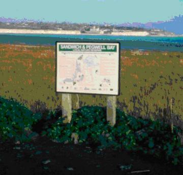 |
Example of a Kent Wildlife Trust interpretation board used on all reserves |
Prescriptions for provision of interpretation
boards
11.1 Managers to produce two interpretation boards – one on the history, the
second on the wildlife of the Common.
11.2 Managers to consider involving the community in the research, design &
production of the boards.
5.11 To monitor the impact of work on the
wildlife of the Common and on the opinions of the local residents.
Sites that are being managed should be monitored as this enables checks to be
made to ensure that management is being undertaken in accordance with the
management plan and to assess the impact of the management on the habitats and
species concerned. This in turn enables informed discussion and should allow for
amendments to the management programme if necessary.
Monitoring may be detailed e.g. recording at the species level, or it may be
very general e.g. using photography to monitor events such as pond clearance or
fencing works.
The monitoring suggested here is a combination of both.
General Monitoring
It is recommended that photographs are taken of the ongoing management on the
site. This could be a community event, a long term school project, or the
responsibility of a single individual. The photographs should record capital
projects such as the installation of cattle grids, the fencing, the grazing, the
pond clearance work, educational events, the interpretation boards, etc. They
can also be used to photograph one-off events such as fire, or the first
sighting of a particular species.
Fixed point photographs can sometimes be useful at recording long-term changes
of a specific area. Fixed point simply means that photographs are taken from the
same spot each year. Practically, this means using a landmark such as a tree or
building to record the location. Taking a GPS reading may also be helpful. This
type of photography may be valuable for recording the development of new areas
of heathland.
It is important that the photograph should record the date, the location and the
event as well as the name of the photographer.
Detailed Monitoring
Some of the management work is very specialised, such as cutting the heather to
encourage new growth and creating new areas of heathland. The heather blocks to
the east of the Bossingham Road in Compartment 2 should be visited the year
after the first block has been cut in order to check that the heather is growing
new shoots. If the cutting has not been successful, no further cutting should
take place until further advice has been sought.
Likewise, if one small area of ground is turf stripped and the heather cuttings
strewn, it is important to know that new heather is developing before any
additional areas are created. Again, this will involve a single visit one year
after the strewing to assess the success of the project.
The reptiles and amphibians should also be monitored, particularly with respect
to the great crested newt. This can be carried out by the local residents
following attendance at the training day offered by Dr Lee Brady.
It is also recommended that the Managers and local residents agree a suitable
forum to swap information about what is happening on the Common.
Prescriptions for monitoring the impact of work
on the wildlife of the Common and on the opinions of the local residents.
12.1 Use photography to record events and long-term changes on the Common.
12.2 Monitor heathy areas.
12.3 Monitor reptiles.
12.4 Monitor amphibians.
12.5 Encourage the adhoc collection of records.
12.6 Managers and local residents to agree a suitable forum to swap information
and concerns about what is happening on the Common.
6 PROJECT REGISTER
This Chapter describes the individual projects that will need to be undertaken
during the life of this management plan. Each project is shown on a separate
sheet and contains sufficient information to enable the task to be completed
successfully. It provides information on:
The work that will need to be undertaken.
The organisation or type of person responsible for undertaking the task.
The type of equipment needed.
The compartments where the work should be undertaken.
The timing of the project.
The cost.
Please note that each sheet also has a column where
information can be recorded to say that the job was completed.
The content of this page is not the direct responsibility of Stelling Minnis Parish Council.
Page designed and produced for Stelling Minnis Parish Council by Nick Smith - 25 January 2009
Web site url and hosting facilities provided by Simon Wood of Terabyte Computing Ltd
Page designed and produced for Managers of Stelling Minnis Common and Stelling Minnis Charitable Trust by Nick Smith
amended - 12 October 2013
Web site url and hosting facilities provided by Simon Wood of Terabyte Computing Ltd